Loddiswell
| Loddiswell | |
| Devon | |
|---|---|
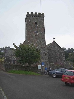
 St Michaels and All Angels, Loddiswell | |
| Location | |
| Grid reference: | SX719485 |
| Location: | 50°19’23"N, 3°48’-0"W |
| Data | |
| Post town: | Kingsbridge |
| Postcode: | TQ7 |
| Local Government | |
| Council: | South Hams |
Loddiswell is a village in the south of Devon, on the west side of the River Avon or Aune, three miles north of Kingsbridge.[1]
There is evidence of occupation going back to Roman times. The name 'Loddiswell' is a corruption of Saint Loda's well, named after one of the many local saints who were active all over the West Country in the 'Age of Saints'.
The parish church of St Michael's and All Angels, is of the 14th century, enlarged in the 15th century; its font is Norman.
History
There is evidence at the northern end of this parish that Blackdown hill was used by the Romans,[2] on the hill Blackdown Rings,[3] a ring-and-bailey hill fort, may be the remains of a wooden fortress of the 12th century, not otherwise documented.[4] The hill itself gives a commanding view of the area.

Loddiswell was mentioned in the Domesday Book in 1086, in which the manor is valued at 100 shillings. The manor then belonged to Juhel of Totnes, but had belonged to an Englishman named Heca before the Norman Conquest. Domesday recorded that there was a fishery that gave 30 salmon as geld.[5]
The source of the village's mediæval prosperity was wool. Woolston House, the manor house of Staunton manor, is a 17th-century house built near the foundations of an earlier structure; rebuilt in the 18th century, it passed from the Wise/Wyse family to the Weymouth and Allin families.[6]
A copper mine opened in the parish in 1825.
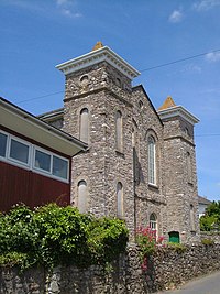
In 1848, the congregationists built a chapel[2] funded by Richard Peek. This locally born philanthropist who retired to Loddiswell and built Hazlewood House (1830). also funded a local school (The British School), a reading and news room (1838) as well as giving to various other nearby chapels.
In 1850, the village had a population of 1,013 and the church (St Michael's) was then described as ancient. Yellow ochre was collected here for resale complementing the employment at the mine and the mill.[7][8]
The Great Western Railway's Kingsbridge branch line arrived in 1893 with a stop at Loddiswell station. It was said that Loddiswell was a "brisk walk away" as in fact the station was closer to the less well known and smaller village of Woodleigh.[9] The railway station continued through the steam age but by 1961 it was an unmanned halt and in 1963 it closed for ever.[9] Today the remains of the track is used as a walking route.
The village today
Modern Loddiswell is well served for a small village. There is still a Post Office, Mini Supermarket and village public house, the Loddiswell Inn. The South Devon Chilli Farm can be found just to the north of the village.
Near the village is Fosse Copse a four-and-a-half-acre woodland on the west facing slope of the Avon Valley owned and managed by the Woodland Trust.[10]
References
- ↑ Devon County Council: Loddiswell
- ↑ 2.0 2.1 Morris and Co.'s Commercial Directory and Gazetteer, 1870, accessed April 2009
- ↑ Blackdown Rings, Loddiswell
- ↑ Devon County council: Loddiswell
- ↑ 'Domesday Book: A Complete Translation' (Penguin, 2003) ISBN 0-14-143994-7; p.306
- ↑ Weymouth Probates in England from 1858 to 1968
- ↑ Information on Loddiswell from GENUKI
- ↑ 'Whites Directory', 1850
- ↑ 9.0 9.1 Loddiswell station, Nostagia site, accessed April 2009
- ↑ "Fosse Copse". Woodland Trust. http://www.woodlandtrust.org.uk/visiting-woods/wood/4280/fosse-copse/. Retrieved 3 July 2016.