Trantlemore
| Trantlemore Gaelic: Tranntail Mòr | |
| Sutherland | |
|---|---|
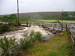
 The Millburn in spate below Trantlemore | |
| Location | |
| Grid reference: | NC891530 |
| Location: | 58°27’6"N, 3°54’3"W |
| Data | |
| Post town: | Forsinard |
| Postcode: | KW13 6 |
| Local Government | |
| Council: | Highland |
| Parliamentary constituency: |
Caithness, Sutherland and Easter Ross |
Trantlemore is a small remote linear crofting township, on the west bank of the River Halladale, in eastern Sutherland. It is opposite Trantlebeg, the latter on the river's east bank and on the main road, the A897 road, up the dale.
Trantlemore is linked to the A897 by a small bridge above the hamlet and at Millburn below it.
The remains of two ancient brochs are found near Trantlemore.