Haroldston West
| Haroldston West | |
| Pembrokeshire | |
|---|---|
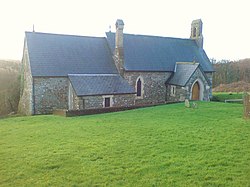
 St Madoc's Church | |
| Location | |
| Grid reference: | SM862147 |
| Location: | 51°47’24"N, 5°6’-0"W |
| Data | |
| Post town: | Haverfordwest |
| Postcode: | SA61 |
| Local Government | |
| Council: | Pembrokeshire |
| Parliamentary constituency: |
Preseli Pembrokeshire |
Haroldston West is a rural coastal parish in the Roose Hundred of Pembrokeshire, 5½ miles west of Haverfordwest[1]. It forms part of the civil community of Merlin's Bridge.
History
A number of prehistoric remains exist in the parish.[2]
In 1833 Haroldston West had a population of 155. Its name is taken from that of an Anglo-Norman who held local lands.[1]
In 1872 the population was 149, living in 28 houses in an area of 1,718 acres.[3]
Church
The parish church is dedicated to St Madoc of Ferns.[4] Before the 1880s the church was a "barn-like old church of nave and chancel with big sash windows and a makeshift roof of salvaged ships' timbers" but had become derelict. It was rebuilt in 1885.[5]
References
| ("Wikimedia Commons" has material about Haroldston West) |
- ↑ 1.0 1.1 "GENUKI: Haroldston West". http://www.genuki.org.uk/big/wal/PEM/HaroldstonWest/index.html. Retrieved 25 April 2015.
- ↑ "Royal Commission on the Ancient and Historical Monuments of Wales". HMSO. 1925. p. 107. https://books.google.co.uk/books?id=qcOwIMflx7AC&pg=PA455&lpg=PA455&dq=haroldston+west+church&source=bl&ots=4OwZ634rem&sig=6gx06RIBjDGkh8qvkNUnFA0iibw&hl=en&sa=X&ei=_Nw6VYDVNYLoaryfgYgD&ved=0CCYQ6AEwATgU#v=onepage&q=haroldston%20west%20church&f=false. Retrieved 25 April 2015.
- ↑ "A Vision of Britain:Haroldston West". http://www.visionofbritain.org.uk/place/2803. Retrieved 25 April 2015.
- ↑ "St Madoc of Ferns". http://parish.churchinwales.org.uk/d293/churches-en/st-madoc-of-ferns_-en/. Retrieved 25 April 2015.
- ↑ Lloyd, Orbach & Scourfield (2004). "Pembrokeshire". Yale University Press. p. 200. https://books.google.co.uk/books?id=AyK4f2_8H78C&pg=PA200&lpg=PA200&dq=haroldston+west+church&source=bl&ots=3gO1xxNc6N&sig=Uduy6fGNu0SlFJRCZLNCCCDdjCo&hl=en&sa=X&ei=_Nw6VYDVNYLoaryfgYgD&ved=0CDMQ6AEwBDgU#v=onepage&q=haroldston%20west%20church&f=false. Retrieved 25 April 2015.
