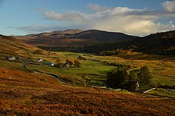
Croick, Ross-shire
| Croick Gaelic: A' Chròic | |
| Ross-shire | |
|---|---|
 Croick | |
| Location | |
| Grid reference: | NH455915 |
| Location: | 57°53’12"N, 4°36’27"W |
| Data | |
| Post town: | Ardgay@ |
| Postcode: | IV24 |
| Local Government | |
| Council: | Highland |
| Parliamentary constituency: |
Caithness, Sutherland and Easter Ross |
Croick is a small, inland crofting village on the north bank of the Black Water which feeds into the River Carron just below the village, in Strathcarron. Forsinard, in north-eastern Ross-shire.
The church in the village was designed by Thomas Telford and built in 1827.[1] In 1845 families evicted from the Glencalvie estate as part of the Highland Clearances camped in the churchyard.[2]
Outside links
| ("Wikimedia Commons" has material about Croick, Ross-shire) |
References
- ↑ "Croick: Overview". Gazetteer for Scotland. http://www.scottish-places.info/towns/townfirst4542.html. Retrieved 30 December 2017.
- ↑ Croick Decanter used to feed babies gifted to museum: Steven McKenzie on BBC News 12 August 2015
