Stanton by Bridge
| Stanton by Bridge | |
| Derbyshire | |
|---|---|
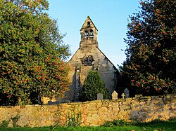
 St Michael's Church is on high ground | |
| Location | |
| Grid reference: | SK372273 |
| Location: | 52°50’31"N, 1°26’53"W |
| Data | |
| Population: | 246 (2011) |
| Post town: | Derby |
| Postcode: | DE73 |
| Local Government | |
| Council: | South Derbyshire |
Stanton by Bridge is a village and parish in Derbyshire. The population of the civil parish at the 2011 census was 246.[1]
Description
St Michael's Church is on some of the highest ground. The church mostly dates from the 13th and 14th centuries, though with some Norman stonework. The porches and roofs of the church were rebuilt in 1860.[2]
As its name suggests Stanton by Bridge is located next to a major bridg: the ancient Swarkestone Bridge, which carries the main A514 road over the River Trent.
References
| ("Wikimedia Commons" has material about Stanton by Bridge) |
- ↑ "Civil Parish population 2011". Neighbourhood Statistics. Office for National Statistics. http://www.neighbourhood.statistics.gov.uk/dissemination/LeadKeyFigures.do?a=7&b=11128990&c=Stanton+by+bridge&d=16&e=62&g=6414972&i=1001x1003x1032x1004&m=0&r=1&s=1459431408580&enc=1. Retrieved 31 March 2016.
- ↑ Stanton by Bridge, Philip Heath, Conservation area report, accessed April 2011

This Derbyshire article is a stub: help to improve Wikishire by building it up.
