Luffincott
| Luffincott | |
| Devon | |
|---|---|
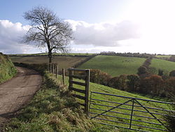
 The lane to West Peeke Farm, Luffincote | |
| Location | |
| Grid reference: | SX333946 |
| Location: | 50°43’38"N, 4°21’45"W |
| Data | |
| Local Government | |
| Council: | Torridge |
| Parliamentary constituency: |
Torridge and West Devon |
Luffincott is a tiny hamlet in the far west of Devon, consisting of a farm, a small, closed church and little else, all at the end of a dead-end lane, but with another hamlet, Luffincote Shop at the head of the lane. It gives its name too to a wider parish. Luffincote's lane runs west almost to the bank of the River Tamar, which forms the border with Cornwall to the west, and which is not bridged here. Footpaths run through the hamlet to north and south along the valley.
The hamlet is about six miles south of the town of Holsworthy.
The parish is surrounded clockwise from the north by the parishes of Tetcott, Ashwater, St Giles on the Heath and Northcott. Its western border is the Tamar.[1]
The civil parish population was recorded as just 45 in 2001: a hundred years before it had been 62. Luffincote is no longer a church parish but is part of the Parish of Tetcott.[2]
The name Luffincott has a variety of early forms, first appearing in documents as Leghygnecoth′ in 1242 with variants such as Loghingecote (1285), Lughyngcote (1330), Loghynton que vocatur Loghyngecote (1346) and Luffencote (1577). Its derivation is believed to be form the Old English Luhingas ('clan of Luha') and cot; a cottage or small settlement.[3]
Church and farm

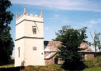
The old parish church, St James's Church, stands in its churchyard at the end of the lane, looking down towards the Tamar. It is a Grade I listed building.[4] It was declared redundant in 1975.
The church stands near the farmyard of Luffincott Barton, a mid-19th-century farmhouse and out-buildings which were part of the Tetcott estate. According to Pevsner, Luffincott Barton is the only other building of interest in the parish.[5]
| ("Wikimedia Commons" has material about Luffincott) |
References
- ↑ "Map of Devon Parishes". Devon County Council. http://www.devon.gov.uk/devon_districts_2002_.pdf. Retrieved 20 June 2013.
- ↑ Harris, Helen: 'A Handbook of Devon Parishes' (Halsgrove, 2004), page 168 ISBN 1-84114-314-6
- ↑ Gover, J. E. B. & Mawer, A. & Stenton, F.M.: 'Place-Names of Devon , Part' (English Place-Names Society, 1931/2), page 152
- ↑ National Heritage List @: St James Church, Luffincote
- ↑ Nikolaus Pevsner: The Buildings of England: Devon, 1952; 1989 Penguin Books ISBN 978-0-300-09596-8
