North Scale
| North Scale | |
| Lancashire | |
|---|---|
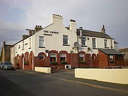
 The Crown, North Scale | |
| Location | |
| Island: | Walney Island |
| Grid reference: | SD180700 |
| Location: | 54°7’11"N, 3°15’18"W |
| Data | |
| Post town: | Barrow-in-Furness |
| Postcode: | LA14 |
| Dialling code: | 01229 |
| Local Government | |
| Council: | Westmorland & Furness |
| Parliamentary constituency: |
Barrow and Furness |
North Scale is a village and one of only four settlements on Walney Island. It is the northernmost settlement, lying a mile north of Vickerstown.
History
North Scale was first identified as an agricultural settlement, owned by Furness Abbey, in 1247.[1]
As a royalist stronghold in the Civil War it was briefly sieged by Parliamentarians.
In 1865, the Crown Inn opened in North Scale.[2]
Before the Jubilee Bridge to Walney Island opened in 1908, people crossing on foot at low tide would arrive near North Scale. A causeway was built to make crossing possible for longer periods.[3]
Modern development
The village grew with the development of the Red Ley estate in the 1960s and the Barnes estate in the 1970s.[4]
North Scale has a community centre, and is linked by bus services to the rest of Walney Island, and to Barrow-in-Furness, via the Jubilee Bridge.
The village is home to the Lakes Gliding Club.[5]
Outside links
| ("Wikimedia Commons" has material about North Scale) |
