Brathay
| Brathay | |
| Lancashire | |
|---|---|

| |
| Location | |
| Grid reference: | NY351031 |
| Location: | 54°24’36"N, 3°0’0"W |
| Data | |
| Post town: | Ambleside |
| Postcode: | LA22 |
| Dialling code: | 01539 |
| Local Government | |
| Council: | Westmorland & Furness |
| Parliamentary constituency: |
Westmorland and Lonsdale |
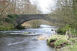
Brathay is a hamlet and ecclesiastical parish in Lancashire, adjacent to the border with Westmorland, marked here by the River Brathay. It is situated a mile south-west of Ambleside, close to the northern shores of Windermere.
It was constituted as a chapelry in the ancient parish of Hawkshead in 1853. Brathay Hall and the surrounding estate belong to a charity, the Brathay Trust.

This Lancashire article is a stub: help to improve Wikishire by building it up.