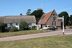
Down St Mary
| Down St Mary | |
| Devon | |
|---|---|
 The Green, Down St Mary | |
| Location | |
| Grid reference: | SS743044 |
| Location: | 50°49’33"N, 3°47’8"W |
| Data | |
| Population: | 316 (2001) |
| Post town: | Crediton |
| Postcode: | EX17 |
| Dialling code: | 01363 |
| Local Government | |
| Council: | Mid Devon |
| Parliamentary constituency: |
North Devon |
Down St Mary is a small village in the cebntre of Devon, to be found off the A377 road with no towns near it. Its nearest neighbours are similarly sized villages such as Zeal Monachorum a mile and a half to the west and Copplestone two miles to the south-east.
The parish had a recorded population of just 316 in 2001.
Outside links
| ("Wikimedia Commons" has material about Down St Mary) |
