Churchstow
| Churchstow | |
| Devon | |
|---|---|
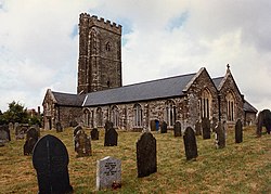
 St Mary's Church, Churchstow | |
| Location | |
| Grid reference: | SX712458 |
| Location: | 50°17’56"N, 3°48’32"W |
| Data | |
| Population: | 465 (2011) |
| Post town: | Kingsbridge |
| Postcode: | TQ7 |
| Dialling code: | 01548 |
| Local Government | |
| Council: | South Hams |
| Parliamentary constituency: |
Totnes |
| Website: | www.churchstow-devon.co.uk |
Churchstow is a small village in southern Devon, on the A379 road two miles north-west of Kingsbridge and sixteen miles south-east of Plymouth. The parish had a population of 465 in 2011, according to the Census of that year.
Parish church
The parish church is St Mary's, standing in a prominent position atop a high ridge. It is a 14th century church and is a fine example of churches built during this time in the south of Devon. The building is made using local dark slate. It is a Grade II* listed building.[1]
The chuch gives the village its name, which means "church place".
History

Churchstow was the parent town of Kingsbridge. The latter founded effectively in 1219 at a bridge at the head of the estuary, then in Churchstow parish, when the Abbot of Buckfast was granted the right to hold a market there.
The village has one public house, the Church House Inn. Built in the 17th century, the building is made from green slate.[2]
Nearby villages include Thurlestone, Aveton Gifford and Loddiswell.
Outside links
References
- ↑ Church of St Mary, Churchstow - British Listed Buildings
- ↑ Church House Inn