Tremain
| Tremain | |
| Cardiganshire | |
|---|---|
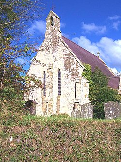
 St Michael's parish church | |
| Location | |
| Location: | 52°6’34"N, 4°34’50"W |
| Data | |
| Post town: | Cardigan |
| Postcode: | SA43 |
| Dialling code: | 01239 |
| Local Government | |
| Council: | Ceredigion |
Tremain is a hamlet and ancient parish in Cardiganshire, some four miles north-east of the county town, Cardigan. The hamlet itself lies along the A487 road, just to the south-west of West Wales Airport. Alternate spellings include Tre-Main, Tre-maen, and Tremaen. The name, signifying " the town of the stone," is said to derive from the vast stone called Llêch yr Ast.
The parish church of St Michael, just to the south of the A487, is a Grade-II* listed building.[1]
References
- ↑ "Church of St Michael, Y Ferwig". British Listed Buildings. http://www.britishlistedbuildings.co.uk/wa-15871-church-of-st-michael-y-ferwig. Retrieved 19 December 2013.
Outside links

This Cardiganshire article is a stub: help to improve Wikishire by building it up.