Wheelton
| Wheelton | |
| Lancashire | |
|---|---|
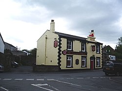
 The Red Lion public house | |
| Location | |
| Grid reference: | SD603211 |
| Location: | 53°41’6"N, 2°36’4"W |
| Data | |
| Population: | 956 (2011) |
| Post town: | Chorley |
| Postcode: | PR6 |
| Dialling code: | 01254 |
| Local Government | |
| Council: | Chorley |
| Parliamentary constituency: |
Chorley |
Wheelton is a village and civil parish in Lancashire north-east of Chorley. According to the United Kingdom Census 2001 it has a population of 1,001, reducing to 956 at the 2011 Census.[1] The village is located on the A674 Chorley–Blackburn road.
There are two communities: Wheelton, which is close to the Leeds and Liverpool Canal and borders Whittle-le-Woods; and Higher Wheelton which is located on the road from Chorley to Blackburn. It is one of the more affluent parts of Lancashire owing to easy motorway access and a semi-rural setting.
References
Outside links
| ("Wikimedia Commons" has material about Wheelton) |
- Wheelton chorley.gov.uk.
- heapeyandwheelton.org

This Lancashire article is a stub: help to improve Wikishire by building it up.
