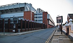
Anfield
| Anfield | |
| Lancashire | |
|---|---|
 Anfield Road | |
| Location | |
| Grid reference: | SJ367933 |
| Location: | 53°25’16"N, 2°57’11"W |
| Data | |
| Population: | 14,510 (2011) |
| Post town: | Liverpool |
| Postcode: | L4, L5, L6 |
| Dialling code: | 0151 |
| Local Government | |
| Council: | Liverpool |
| Parliamentary constituency: |
Liverpool Walton |
Anfield is a district of Liverpool, Lancashire. The population of the ward at the time of the 2011 census was 14,510.[1] The district has been home to football club Liverpool F.C. since the club's founding in 1892.
Toponymy
Originally common pasture land within the parish of Walton on the Hill, the area had the name of Hanging-fields or Hangfield - the name originating from the deeply sloping (or 'hanging') nature of the terrain. The name was also frequently written as Hongfield or Honghfield. In Gore's paper of 26 July 1810, certain fields are advertised as "Fields in Walton-on-the-Hill, called Hanging-fields"
Development
In 1836 the area was made part of Liverpool. The Ordnance Survey map from 1851 shows a house here called Anfield House (then described as Annfield House), around which the district developed.[2] For many years the Graves family were business owners in New Ross, Co. Wexford. Robert Samuel Graves left his home in Rosbercon Castle and headed to Liverpool about the year 1860. He took on the running of the Graves shipping company in the city and he was elected mayor of Liverpool as well as a Member of Parliament for the area in 1865. In his capacity as mayor, it was he who put through a proposal to develop grounds on the outskirts of the city for a Liverpool Football Club.
These grounds ran directly behind the family business. Robert then sanctioned a proposal to build a roadway up to the new grounds, and duly named it Anfield Lane, after the one beside his ancestral home in Rosbercon Castle, New Ross. The Graves family home in New Ross was in the townland of Annefield. Annefield Lane ran just above Rosbercon Castle, and Samuel Robert Graves chose that name for his Liverpool home. Shortened to Anfield, it became the name for part of the city and today survives most famously as the name of the home of Liverpool Football Club - Anfield Stadium.
Most of the houses in Anfield are terraced houses from the late 19th and early 20th centuries. This type of property is particularly dense around Anfield stadium, although in 1991 the properties in Kemlyn Road were demolished to make way for a new stand at Anfield stadium.
In line with other Victoria-era developments, Anfield gained a number of churches, including:
- Church of England:
- St Columba, Pinehurst Road
- St Margaret, Belmont Road
- St Simon and St Jude, Anfield Road
- Roman Catholic:
- All Saints, Oakfield Park
- Wesleyan Methodist:
- Oakfield Road
From 1863, the City Council developed the 120-acre Priory Road Cemetery, to which later was added a crematorium.[3]
Landmarks
Besides Anfield Stadium, the area also contains Stanley Park, one of Liverpool's grand Victorian parks, covering 110 acres of Anfield and is the primary separator between Anfield Stadium and Goodison Park in Walton. Liverpool F.C. have speculated for a long time about building a new stadium in Stanley Park.
Notable residents
- Kerrie Hayes
- Alexei Sayle
- Chris Shepherd
- William Herbert Wallace
- Ricky Tomlinson
- Rebecca Ferguson
- Bobby Willis
- Vincent Cavanagh and Daniel Cavanagh
The Whitney gang also lived in Anfield.[4]
References
- ↑ "City of Liverpool population 2011". http://www.neighbourhood.statistics.gov.uk/dissemination/LeadKeyFigures.do?a=7&b=13689394&c=Anfield&d=14&e=62&g=6349434&i=1001x1003x1032x1004&m=0&r=1&s=1452529247277&enc=1. Retrieved 11 January 2016.
- ↑ "Anfield OS sixth-inch map, Anfield 1851". National Library of Scotland. 22 September 1851. http://maps.nls.uk/view/102344096. Retrieved 17 April 2017.
- ↑ "Priory Rd, Cemetery, Anfield". GENUKI. http://www.genuki.org.uk/big/eng/LAN/WaltonontheHill/PrioryRdCemetery.shtml. Retrieved 21 November 2015.
- ↑ "Last member of Anfield Whitney drugs gang extradited from Spain". Liverpool Echo. 24 November 2011. http://www.liverpoolecho.co.uk/liverpool-news/echo-districts/anfield-walton-echo/anfield-walton-news/2011/11/24/last-member-of-anfield-whitney-drugs-gang-extradited-from-spain-100252-29835866/. Retrieved 21 November 2015.
- The District Placenames of Liverpool, Henry Harrison, 1898
Outside links
| ("Wikimedia Commons" has material about Anfield) |
