Holyhead Mountain
| Holyhead Mountain | |||
| Anglesey | |||
|---|---|---|---|
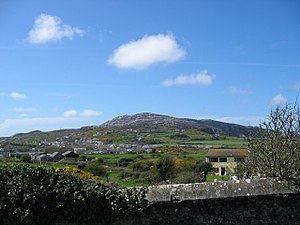
 Holyhead Mountain from the town | |||
| Holy Island, Anglesey | |||
| Summit: | 722 feet SH218829 53°18’47"N, 4°40’35"W | ||
Holyhead Mountain is the highest hill on Holy Island, Anglesey, and the highest point in the county of Anglesey. Its Welsh name is Mynydd Twr, meaning 'tower mountain'.
The hill lies about two miles west of the town of Holyhead, and slopes steeply down to the Irish Sea on two sides. A late Roman watchtower, called Caer y Tŵr (Tower Fortress) stands on the east side of the hill, once guarding this edge of the empire against wild, sea-borne raiders. Holyhead Mountain also has an Iron Age Stone Circle settlement and the material for the Breakwater was quarried from the Mountain too. It is the first sight of land which travellers have when sailing from Dublin to Holyhead.
Holyhead Mountain attracts many visitors, and it is also located close to South Stack lighthouse and many people come here to see the variety of birds which nest along the cliff faces near South Stack.