Swadlincote
| Swadlincote | |
| Derbyshire | |
|---|---|
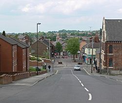
 Hill Street looking toward High Street | |
| Location | |
| Grid reference: | SK298197 |
| Location: | 52°46’26"N, 1°33’25"W |
| Data | |
| Population: | 36,000 (2004 est.) |
| Post town: | Swadlincote |
| Postcode: | DE11 |
| Dialling code: | 01283 |
| Local Government | |
| Council: | South Derbyshire |
| Parliamentary constituency: |
South Derbyshire |
Swadlincote is a town in southern Derbyshire. It stands thirteen miles south of the city of Derby, and east of Burton on Trent. The population of Swadlincote with its surrounding villages is approximately 36,000, and is reckoned as made up of Swadlincote, Church Gresley, Midway and Newhall.
The town has a modest town centre - a local centre for the surrounding villages.
History
The name "Swadlincote" is assumed to derive from the Old English Swartlinges Cottas ("Swartling's cottages").[1] At the time of the Domesday Survey of 1086 Swadlincote was just a small manor. Although the first extraction of minerals in the area is recorded at the end of the thirteenth century, the area remained rural until the industrial revolution of the eighteenth century.
The presence of coal and clay in the area led to urbanisation as colleries, brickworks and potteries came to dominate Swadlincote. These industries continued to expand until the Second World War.[2]
Economy
The town originally had a strong manufacturing heritage that made pipes and earthenware etc. It was the centre of the South Derbyshire coalfield but mining ceased in the early 1990s (Rawdon colliery closed in 1993). Light manufacturing and service companies are sited on industrial estates.
References
Outside links
| ("Wikimedia Commons" has material about Swadlincote) |
