Widdington
| Widdington | |
| Essex | |
|---|---|
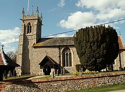
 St Mary's church, Widdington | |
| Location | |
| Location: | 51°57’46"N, -0°13’45"E |
| Data | |
| Population: | 504 |
| Post town: | Saffron Walden |
| Postcode: | CB11 |
| Dialling code: | 01799 |
| Local Government | |
| Council: | Uttlesford |
Widdington is a village and a parish in the Uttlesford hundred of Essex, near Saffron Walden. The population of the civil parish at the 2011 census was 504.[1] The village is located near the M11 motorway. Widdington has a church dedicated to St Mary the Virgin.[2] Prior's Hall, now a private residence, is a rare survival of a stone-built structure from the late tenth or early eleventh centuries; Prior's Hall barn, from the fourteenth century, is nearby.[3][4]
Widdington was recorded in the Domesday Book as Widituna.[5] The entry reads: Widi(n)tuna: St Valery Abbey; Robert from Robert Gernon; Ranulf Peverel.
References
- ↑ "Parish population 2011". http://www.neighbourhood.statistics.gov.uk/dissemination/LeadKeyFigures.do?a=7&b=11130640&c=CB11+3RZ&d=16&e=62&g=6426362&i=1001x1003x1032x1004&m=0&r=0&s=1443282958741&enc=1. Retrieved 26 September 2015.
- ↑ St Mary the Virgin, Widdington - Essex | Diocese of Chelmsford
- ↑ Prior's Hall Barn, Widdington, Essex:: OS grid TL5331 :: Geograph Britain and Ireland
- ↑ Smith, Nicola (July 2012). "The Anglo-Saxon mystery of Prior's Hall". British Archaeology (York: Council for British Archaeology) (125): 40–43. SSN 1357-4442.
- ↑ "Widdington in the Domesday Book". The National Archives. http://www.nationalarchives.gov.uk/documentsonline/search-results.asp?query=place%3Dwiddington&first_date=&last_date=&CatID=24&mediaArray=*&pageNumber=1&searchType=powersearch&queryType=1&sortSpec=first%5Fdate+desc.
Outside links

This Essex article is a stub: help to improve Wikishire by building it up.