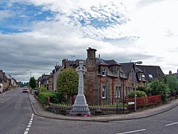
Maryburgh
| Maryburgh | |
| Ross-shire | |
|---|---|
 War memorial, Maryburgh | |
| Location | |
| Grid reference: | NH540562 |
| Location: | 57°34’31"N, 4°26’34"W |
| Data | |
| Post town: | Dingwall |
| Postcode: | IV7 |
| Dialling code: | 01349 |
| Local Government | |
| Council: | Highland |
| Parliamentary constituency: |
Ross, Skye and Lochaber |
Maryburgh is a village in Ross-shire. It stands in Easter Ross, on the northern bank of the River Conon, 2 miles south of the county town, Dingwall. The village of Conon Bridge stands on the other side of the river.
History
Maryburgh is a relatively recently founded village, for while there were estates and farmsteads hereabouts from early days, Maryburgh itself was created in 1815, the year which marked the end of the generation-long Napoleonic Wars by Mary Elizabeth Frederick Mackenzie, from whom it was named. In that year she returned to the family estate of Brahan Castle on the death of her father.
Here she came to a place where a new road had been driven through to Dingwall and a new road bridge over the Conon, opened in 1809, making this spot an attractive place for a new town. Roadmen labouring here had created a settlement on which it could be founded.
At about the same town, the village of Conon Bridge was built.
Maryburgh was created on the estates of Brahan, Brekanord and Balblair, in order to house the estate workers of Brahan. Many of these were men who had been displaced from their Highland villages in the Clearances, many from the old cottages higher in Strathconon.
Each estate worker brought to Maryburgh was allocated a cottage and narrow strip of land for their own cultivation, known in crofting as a "rig". These were each of about an acre stretching down to the River Conon, and are known locally as the ‘Maryburgh Acres’.
In 1841, the population of Maryburgh numbered 403 and by 1870 the community had grown to the extent of 45 houses, rising to 350 after the War and an adult population then of about 850.
By 1885 the Ordnance Survey recorded that Maryburgh had a Post Office, a Free Church, an inn, a public school, a Brick and Tile Works, Carden Mill, Corn and Meal Mill and a Lint and Snuff Mill.
The village
The heart of the village today is along Probyn Street, and here are some of its oldest houses. One of the oldest, "Sunnyholm", is dated 1828.
Older yet amongst the cottages is "Peartree Cottage", at the top of Hood Street, on which the building date of 1824 is inscribed on the skewputt (the lowest stone on the gable). This cottage and the others occupying the same side of the street were originally thatched.