Church Brough
| Church Brough | |
| Westmorland | |
|---|---|
 Church Brough, and Brough Castle | |
| Location | |
| Grid reference: | NY794141 |
| Location: | 54°31’19"N, 2°19’10"W |
| Data | |
| Local Government | |
Church Brough is a village attached to Brough in Westmorland. The town of Brough itself, otherwise known as Market Brough, stands to the north and Church Brough to the south: the two are these days divided far more physically than once they were, as the A66 trans-Pennine trunk road slicing through from east to west side passes between Church Brough and Market Brough, interposing a major road junction and flyover system exactly between them.
About the village
The parish church, St Michael's, stands in Church Brough. The church dates from the Norman period, and may have suffered during an attack by King William I of Scotland in 1174. The church was enlarged in the 14th century, and in the early 16th century when most of the existing structure was built. The tower was constructed by Thomas Blenkinsop of Helbeck in 1513. Repairs and improvements continue to this day.

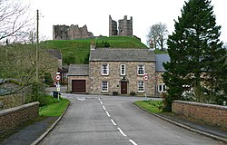
The ruins of Brough Castle also standing in Church Borough. It stands within the more ancient earthworks of a Roman fort, known as Veteris.[1] The castle was built in the 11th century.
The Swindale Beck flows by the village, as does the little Augill Beck, to join the greater river by the castle.
Nearby is Augill Castle, built in 1841 by John Bagot Pearson from Kirkby Lonsdale as a weekend retreat and now a hotel.
Outside links
| ("Wikimedia Commons" has material about Brough, Westmorland) |
References
- ↑ National Heritage List 1007148: Brough Castle and Brough (Verteris) Roman fort and civil settlement
