Wilson
| Wilson | |
| Leicestershire | |
|---|---|

| |
| Location | |
| Grid reference: | SK404246 |
| Location: | 52°49’3"N, 1°24’7"W |
| Data | |
| Post town: | Derby |
| Postcode: | DE73 |
| Dialling code: | 01332 |
| Local Government | |
| Council: | North West Leicestershire |
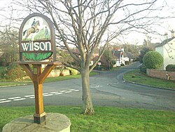
Wilson is a hamlet in the parish of Breedon on the Hill in Leicestershire, adjacent to to the border with Derbyshire. It lies just east of Melbourne in the latter county, close to East Midlands Airport. The county border runs to the west of Wilson, then along the southern part of Main Street, leaving a cluster of buildings to the south of the hamlet in Derbyshire.
Wilson retains many 'village-like' features, including the one pub, the Bulls Head. Wilson has no amenities other than a golf course, gym and swimming pool. Its name is first recorded in the 12th century as Wiuelestunia and likely came from Anglo-Saxon Wifeles tūn = "Wifel's farmstead or village".
| ("Wikimedia Commons" has material about Wilson) |

This Leicestershire article is a stub: help to improve Wikishire by building it up.
