Arnside Knott
| Arnside Knott | |
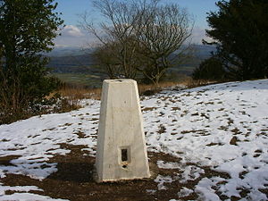
 Arnside Knott Trig Point | |
|---|---|
| Summit: | 522 feet SD456775 54°11’25"N, 2°50’6"W |
Arnside Knott is a hill rising to just 522 feet near Arnside, in the very south of Westmorland, south of the River Kent. It is within the Arnside and Silverdale Area of Outstanding Natural Beauty, and is part of the estates of the National Trust.
Though of modest height, certainly in comparison to Westmorland’s great fells, Arnside Knott is listed as a 'Marilyn', which is to say a hill with at least 150 m of topographic prominence. It is the lowest Marilyn in Britain, and was not included in Alan Dawson's original work in which the Marilyns were first defined and listed, The Relative Hills of Britain.[1] It was added to the list in 2004-05.[2]
The National Trust grazes Highland cattle on Arnside Knott.
Outside links
- Arnside Knott wildlife walk – National Trust
References
- ↑ Dawson, Alan: 'The Relative Hills of Britain' (1992) ISBN 1-85284-068-4 (archive)
- ↑ Dawson, Alan: 'Update to the Relative Hills of Britain' (archive)