Ivegill
| Ivegill | |
| Cumberland | |
|---|---|
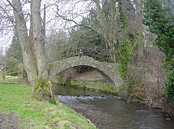
 Wharton Bridge | |
| Location | |
| Grid reference: | NY418531 |
| Location: | 54°46’48"N, 2°54’22"W |
| Data | |
| Post town: | Carlisle |
| Postcode: | CA4 |
| Dialling code: | 016974 |
| Local Government | |
| Council: | Westmorland & Furness |
| Parliamentary constituency: |
Penrith and The Border |
Ivegill is a small village in Cumberland. The village has one place of worship and a school. It is located on an unclassified road near Southwaite services which is on the M6 motorway.
The village takes its name from the River Ive which flows through the centre of the village. Nearby settlements include the villages of Southwaite, Low Braithwaite, Middlesceugh and Highbridge, Cumberland.
The Ive is crossed here by an early eighteenth century humpbacked packhorse bridge, Wharton Bridge, which is a Grade II listed structure.[1]
Outside links
| ("Wikimedia Commons" has material about Ivegill) |
References
- ↑ National Heritage List 1326713: Wharton Bridge
