Geltsdale
| Geltsdale | |
| Cumberland | |
|---|---|
 Geltsdale House | |
| Location | |
| Grid reference: | NY569536 |
| Location: | 54°52’34"N, 2°40’16"W |
| Data | |
| Post town: | Brampton |
| Postcode: | CA8 |
| Dialling code: | 01228 |
| Local Government | |
| Council: | Cumberland |
| Parliamentary constituency: |
Penrith and The Border |
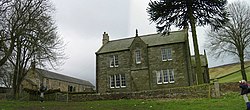
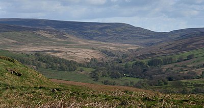
Geltsdale is a dale in Cumberland and a hamlet sitting within the dale (to the southeast of Castle Carrock). The dale is cut by the River Gelt through the midst of the bare upland area known as the King's Forest of Geltsdale.
The Geltsdale Reservoir railway ran in the vicinity.
Protected areas

The local landscapes are under several levels of protection. Two of the protected areas cover a large area:
- the North Pennines Area of Outstanding Natural Beauty
- the North Pennines Moors Special Protection Area (364,000 acres)[1]
The Geltsdale & Glendue Fells Site of Special Scientific Interest has an area of 19,914 acres,[2] and is one of the SSSIs which underlie the SPA.
Geltsdale RSPB reserve is a 12,000-acre nature reserve within the SSSI. It mainly moorland and is managed by the Royal Society for Protection of Birds for upland birds such as black grouse and hen harrier.[3]
Outside links
| ("Wikimedia Commons" has material about Geltsdale) |
References
- ↑ Joint Nature Conservation Committee
- ↑ SSSI listing and designation for Geltsdale & Glendue Fells SSS
- ↑ 'RSPB Where To Go Wild in Britain' page 25 (Dorling Kindersley, 2009) ISBN 978-1-4053-3512-6
