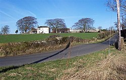
Drumleaning
| Drumleaning | |
| Cumberland | |
|---|---|
 Drumleaning | |
| Location | |
| Grid reference: | NY270518 |
| Location: | 54°51’22"N, 3°8’10"W |
| Data | |
| Post town: | Wigton |
| Postcode: | CA7 |
| Dialling code: | 016973 |
| Local Government | |
| Council: | Cumberland |
| Parliamentary constituency: |
Workington |
Drumleaning is a hamlet in Cumberland, four miles south of Drumburgh on a low ridge near the Wampool.[1]
| ("Wikimedia Commons" has material about Drumleaning) |
References
- ↑ Ekwall, Eilert (1918). Scandinavians and Celts in the north-west of England. C.W.K. Gleerup. p. 89. https://books.google.com/books?id=GugxAQAAIAAJ. Retrieved 19 July 2012.
