Kilfinan
| Kilfinan | |
| Argyllshire | |
|---|---|
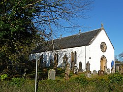
 Kilfinan Parish Church | |
| Location | |
| Grid reference: | NR934788 |
| Location: | 55°57’28"N, 5°18’40"W |
| Data | |
| Post town: | Dunoon |
| Postcode: | PA23 |
| Dialling code: | 01369 |
| Local Government | |
| Council: | Argyll and Bute |
Kilfinan is a hamlet and parish on the Cowal peninsula of Argyllshire. Located on the eastern side of Loch Fyne, the hamlet is four miles from the village of Tighnabruaich on the opposite side of the peninsula.[1] Kilfinan is the burial place of the clan chiefs of the Lamonts, in the 13th-century Kilfinan Parish Church.[2][3]
The parish forms the extreme southern part of Cowal, being separated from Knapdale by Loch Fyne; and from Buteshire by the Kyles of Bute. Stralachan lies to the north, along the western coast, while Kilmodan lies to the north-east.