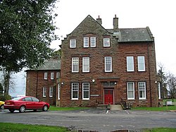
Carleton, Carlisle
| Carleton | |
| Cumberland | |
|---|---|
 Cumberland House, Carleton | |
| Location | |
| Grid reference: | NY426528 |
| Location: | 54°52’1"N, 2°53’35"W |
| Data | |
| Post town: | Carlisle |
| Postcode: | CA1 |
| Dialling code: | 01228 |
| Local Government | |
| Council: | Cumberland |
| Parliamentary constituency: |
Carlisle |
Carleton is a hamlet on the A6 road just a few miles to the south-east of Carlisle city centre, in Cumberland. It stands near the River Petteril.
Nearby is Harraby, which has become a residential area of suburb of Carlisle.
This is one of three villages named 'Carleton' in Cumberland: the name means simply "churl's village" or "free peasant's estate".
Outside links
| ("Wikimedia Commons" has material about Carleton, Carlisle) |
