Pennington, Lancashire
| Pennington | |
| Lancashire | |
|---|---|
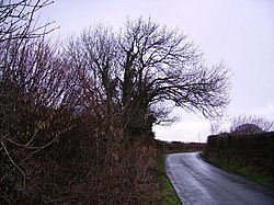
 Country road in Pennington | |
| Location | |
| Grid reference: | SD260770 |
| Location: | 54°10’60"N, 3°7’60"W |
| Data | |
| Population: | 2,008 (2011) |
| Post town: | Ulverston |
| Postcode: | LA12 |
| Dialling code: | 01229 |
| Local Government | |
| Council: | Westmorland & Furness |
| Parliamentary constituency: |
Barrow and Furness |
Pennington is a small village in the Furness district of Lancashire, sitting between Ulverston, Rosside and Lindal-in-Furness, just off the nearby A590, with the nearest train link in Ulverston.
In the early 1870s, Pennington was described as:
- 'PENNINGTON, a parish in Ulverston district, Lancashire; near the Furness railway, 1¾ mile W S W of Ulverston. It has a post-office under Ulverston. Acres, 2, 767. Real property, £18, 436; of which £7, 500 are in mines, and £2, 732 in quarries. Pop. in 1851, 489; in 1861, 879. Houses, 163. The increase of pop. arose from extension of mining operations'.[1]
History
Pennington is mentioned in the Domesday Book as one of the townships forming the Manor of Hougun which was held by Tostig Godwinson, Earl of Northumbria before the Conquest.[2]
To the west, in the nearby hamlet of Rosside, are the earthwork remains of Pennington Castle, a mediæval ringwork.
A runic inscription in the Norse language on a discarded tympanum found in the churchyard has been dated to the 12th century, which is remarkably late for runic script.[3][4]
A set of stocks stand outside the church gate that were formerly used to for robust local punishment offenders. They are no longer in use.
Outside links
| ("Wikimedia Commons" has material about Pennington, Lancashire) |

References
- ↑ Wilson, John Marius (1870). Gazetter of England and Wales. Edinburgh: A. Fullerton & Co.. http://visionofbritain.org/place/10752. Retrieved 27 January 2015.
- ↑ Cumbria: Hougun (The Domesday Book On-Line)
- ↑ Runic Inscription in St Michael's Church, Pennnigton on Viking Minds
- ↑ British History on-Line: The Parish of Pennington A History of the County of Lancaster - Volume : {{{2}}} (Victoria County History)
