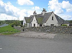
Causeway End, Wigtownshire
| Causeway End | |
| Wigtownshire | |
|---|---|
 Causeway End Cottage | |
| Location | |
| Grid reference: | NX421601 |
| Location: | 54°54’39"N, 4°27’52"W |
| Data | |
| Local Government | |
| Council: | Dumfries and Galloway |
Causeway End is a tiny hamlet at a junction of lanes in Wigtownshire, alongside the A714 which runs from Newton Stewart south to the county town, Wigtown.
This was once a wetland district, hence the 'causeway': the Moss of Cree extends between the hamlet and the tidal reach of the River Cree and its mouth at the head of Wigtown Bay.
Outside links
| ("Wikimedia Commons" has material about Causeway End, Wigtownshire) |
