Gurnard
| Gurnard | |
| Hampshire | |
|---|---|
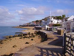
 Gurnard beachfront | |
| Location | |
| Island: | Isle of Wight |
| Grid reference: | SZ478946 |
| Location: | 50°44’58"N, 1°19’26"W |
| Data | |
| Population: | 1,682 (2011) |
| Post town: | COWES |
| Postcode: | PO31 |
| Dialling code: | 01983 |
| Local Government | |
| Council: | Isle of Wight |
| Parliamentary constituency: |
Isle of Wight |
Gurnard is a village on the Isle of Wight, two miles to the west of Cowes. Gurnard sits on the edge of Gurnard Bay, enjoyed by the Gurnard Sailing Club.
Gurnard's main street features a pub (Portland Inn), Doughty Newnham Chartered Surveyors office, a few shops and a few houses. The west end of the beach is Gurnard Marsh and a stream called "The Luck" which discharges into the Solent.
A fortification known as Gurnard Fort was built on a headland west of Gurnard Marsh about 1600. The land was eroded, however, and all traces disappeared until an archaeological excavation of a Roman villa in 1864 uncovered traces of Gurnard Fort as well.
Outside links
| ("Wikimedia Commons" has material about Gurnard) |
- Gurnard Sailing Club
- Isle of Wight Council: Beaches (Gurnard)
- Photos, accommodation guide, hotels and tourist information
