Norton in Hales
| Norton in Hales | |
| Shropshire | |
|---|---|
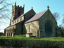
 Church of St Chad, Norton in Hales | |
| Location | |
| Location: | 52°56’38"N, 2°26’35"W |
| Data | |
| Population: | 620 (2011[1]) |
| Post town: | Market Drayon |
| Postcode: | TF9 |
| Dialling code: | 01630 |
| Local Government | |
| Council: | Shropshire |
| Parliamentary constituency: |
North Shropshire |
Norton in Hales is a village and parish in Shropshire, adjacent to the borders with Cheshire and Shropshire. It lies on the A53 road between the town of Market Drayton and Woore, Shropshire's most north-easterly village and civil parish.
Staffordshire is to the east of the parish and Cheshire to the west. Also within the parish is the village of Betton and hamlet of Ridgwardine.
Within the village is Norton in Hales Church of England Primary School, Saint Chad's Church, The Hinds Head Inn, and a large playing field.
Tunstall Hall is a Grade-II*-listed building, built in about 1732, formerly a girls school, is now a residential home offering specialist care in dementia.[2][3]
References
| ("Wikimedia Commons" has material about Norton in Hales) |
- ↑ "Civil Parish population 2011". http://www.neighbourhood.statistics.gov.uk/dissemination/LeadKeyFigures.do?a=7&b=11127147&c=Norton+in+Hales&d=16&e=62&g=6460458&i=1001x1003x1032x1004&m=0&r=1&s=1448797662845&enc=1. Retrieved 29 November 2015.
- ↑ "Tunstall Hall - Norton in Hales - Shropshire - England". British Listed Buildings. http://www.britishlistedbuildings.co.uk/en-260434-tunstall-hall-norton-in-hales-. Retrieved 21 September 2014.
- ↑ "History of Tunstall Hall Care Centre". http://www.stphilipscare.com/news-article.php?n=440. Retrieved 21 September 2014.

This Shropshire article is a stub: help to improve Wikishire by building it up.
