Upper Broughton
| Upper Broughton | |
| Nottinghamshire | |
|---|---|
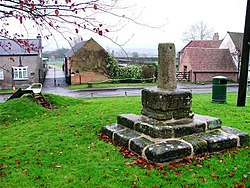
 Village Green, Upper Broughton | |
| Location | |
| Grid reference: | SK682260 |
| Location: | 52°49’39"N, -0°59’19"W |
| Data | |
| Postcode: | LE14 |
| Local Government | |
Upper Broughton, otherwise known as Broughton Sulney is a little village at the edge of the Nottinghamshire Wolds and indeed at the edge of Nottinghamshire. It is just half a mile west of its sister village, Nether Broughton, which sits across the border in Leicestershire.
The A606 road runs through both villages, between Melton Mowbray in Leicestershire and the City of Nottingham.
Parish church
The parish church is known as St Luke, Broughton Sulney. It is a Grade I listed building, of a mixture of centuries: it incorporates the remains of a south arcade built around 1200, and the 13th and 14th centuries provided its north arcade and tower. In 1733 a porch was built. The church underwent a Victorian restoration in 1855 under S S Teulon.[1]
Station

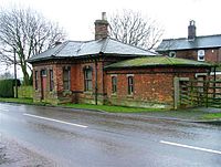
Upper Broughton had a railway station on the Midland Railway route between London and Nottingham. The line still exists today as the Old Dalby Test Track.
The station was opened for passengers on 2 February 1880[2] It was on a cut-off line from Melton Mowbray to Nottingham which assisted London-bound express trains and improved access to and from the iron-ore fields in Leicestershire and Rutland. Local traffic was minimal though and Upper Broughton closed to passengers as early as 1948.[3]
Outside links
References
- ↑ Church of St Luke, Upper Broughton - British Listed Buildings
- ↑ Aldworth, Colin (2012). The Nottingham and Melton Railway 1872 - 2012.
- ↑ Shannon, Paul (2007). Nottinghamshire (British Railways Past and Present). Kettering, Northants: Past & Present Publishing. p. 23. ISBN 978-1-85895-253-6.