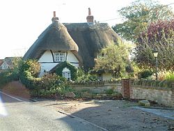
West Hagbourne
| West Hagbourne | |
| Berkshire | |
|---|---|
 West Hagbourne | |
| Location | |
| Grid reference: | SU5187 |
| Location: | 51°35’2"N, 1°15’29"W |
| Data | |
| Population: | 265 (2001) |
| Post town: | Didcot |
| Postcode: | OX11 |
| Dialling code: | 01235 |
| Local Government | |
| Council: | South Oxfordshire |
| Parliamentary constituency: |
Wantage |
| Website: | West Hagbourne village website |
West Hagbourne is a village in Berkshire, within the Berkshire Downs 2 miles south of Didcot.
The village has a public house, the Horse & Harrow, and a Church of England Primary School.
Current developments
The character of the village would be changed by local District Council's plans to expand the town of Didcot. Building development on a large area of land to the west of Didcot, to be known as Great West Park, would add 3,000 houses to Didcot. Further plans for 2010, to a further 3,000 or more houses as part of the South East regional development plan, will further change the nature of the villages that lie on the periphery of the town of Didcot. It is not known how the abolition of regional special strategies will affect the move to absorb West Hagbourne into "Greater Didcot".
Outside links

| ("Wikimedia Commons" has material about West Hagbourne) |
References
Books
- Page, W.H.; Ditchfield, P.H., eds (1924). A History of the County of Berkshire, Volume 4. Victoria County History. pp. 475–484.
