Chapeltown, Lancashire
| Chapeltown | |
| Lancashire | |
|---|---|
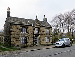
 Old School House, Chapeltown | |
| Location | |
| Grid reference: | SD733157 |
| Location: | 53°38’13"N, 2°24’14"W |
| Data | |
| Post town: | Bolton |
| Postcode: | BL7 |
| Dialling code: | 01204 |
| Local Government | |
| Council: | Blackburn with Darwen |
| Parliamentary constituency: |
Rossendale and Darwen |
Chapeltown is a village in Lancashire, in the area of the old township of Turton, of which Chapeltown was the principal village. The name 'Chapeltown' became attached to the village rather than the original 'Turton' as this was where Turton's first chapel stood.
Chapeltown is on the B6391 north of Bolton, on southern slopes of the West Pennine Moors.
The village today consists mainly of eighteenth and nineteenth century terraced stone cottages. The tight clustering of properties along High Street is typical of villages with mediæval origins. There is a small public garden containing the old village stocks and market cross; the timber elements of these have been renewed several times but the stone bases are original.
Chapeltown is the location of St Anne's Church, founded as a chapel of ease for the villagers of Turton before it became a parish in its own right. Turton Tower stands to the west of the village centre. The local pub is the Chetham Arms.
Cheetham Close, a little hill on which stand prehistoric megaliths, is to the east of Chapeltown, separating it from Turton's other village, Egerton.
Photo gallery
-
The old village stocks
-
St. Anne's Church
-
Arms of the Chetham family above the door of the Chetham Arms pub
Outside links
| ("Wikimedia Commons" has material about Chapeltown, Lancashire) |


