Walterstone
| Walterstone | |
| Herefordshire | |
|---|---|
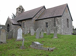
 Walterstone Church | |
| Location | |
| Grid reference: | SO340250 |
| Location: | 51°55’8"N, 2°57’40"W |
| Data | |
| Population: | 97 (2001[1]) |
| Post town: | Hereford |
| Postcode: | HR2 |
| Dialling code: | 01873 |
| Local Government | |
| Parliamentary constituency: |
Hereford and South Herefordshire |
Walterstone is a village and parish in Herefordshire, adjacent to the border with Monmouthshire and the Brecon Beacons National Park, 7½ miles north of Abergavenny and 19 miles south-west of Hereford. The parish had a population of 97 in the 2001 UK Census.[1]
There is a motte-and-bailey castle in the village to the west of St Mary's church and an Iron Age hill fort on high ground half a mile to the east.[2] The River Monnow and the railway line from Newport to Shrewsbury share a valley south east of the village.[3]
The 300-year-old village pub, the Carpenter's Arms, is situated next to the church[4] and has been in the same family for the last 100 years.[5]
In the 18th century, a Roman mosaic was reported to have been found in the parish. The exact site is not known but is thought to be in the Coed-y-Grafel area north of the village.[6] Allt Yr Ynys, a 16th-century manor house a mile south of the village, is now a country house hotel.[2][7]
References
- ↑ 1.0 1.1 "Population of Herefordshire Parishes, 2001" (pdf). Herefordshire Council. 2004. http://www.herefordshire.gov.uk/docs/research/2001_parish_populations.pdf. Retrieved 2010-12-04.
- ↑ 2.0 2.1 Pevsner, Nikolaus (1963). The Buildings of England - Herefordshire. New Haven and London: Yale University Press. pp. 308. ISBN 978-0-300-09609-5.
- ↑ Brecon Beacons National Park - Eastern Area (Explorer Maps) (A3 ed.), Ordnance Survey, 2010, ISBN 978-0-319-24054-0
- ↑ Deeley, Nigel W. "The Carpenters Arms - Walterstone, Herefordshire HR2 0DX". http://www.thecarpentersarmswalterstone.com/location.htm. Retrieved 2016-08-15.
- ↑ "Carpenter's Arms in Walterstone notches up another success". http://www.herefordtimes.com/news/13343702.Carpenter_s_Arms_in_Walterstone_notches_up_another_success/. Retrieved 2016-08-15.
- ↑ "Roman 'pavement', Coed-y-Grafel, Walterstone". Herefordshire Through Time. Herefordshire Council. http://www.herefordshire.gov.uk/htt/smrSearch/Monuments/Monument_Item.aspx?ID=1454. Retrieved 2010-12-05.
- ↑ "Allt Yr Ynys Country Hotel - About us". http://allthotel.co.uk/about-us. Retrieved 2010-12-05.
Outside links
| ("Wikimedia Commons" has material about Walterstone) |
- Walterstone, GENUKI genealogy web portal
- List of monuments in the parish
- Please note that most of the sites are on private property and are not open to the public
- St Mary's Church
