Cessford
| Cessford | |
| Roxburghshire | |
|---|---|
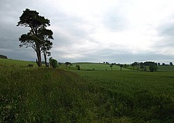
 Cheviot countryside near Cessford | |
| Location | |
| Grid reference: | NT735235 |
| Location: | 55°30’18"N, 2°25’16"W |
| Data | |
| Post town: | Kelso |
| Postcode: | TD5 |
| Local Government | |
| Council: | Scottish Borders |
Cessford is a hamlet about a mile south of the B6401 road, in Roxburghshire.
Places nearby include Crailing, Eckford, Kelso, Morebattle, Nisbet, and Oxnam
Cessford Castle is a ruined castle nearby.
Cessford Burn, a tributary of the Kale Water, flows through the hamlet.
References
- Scott, T (1897) 'Collection of flint arrow-heads, spearheads, knives, scrapers, borers, flakes - about 600 in all - from Craigsfordmains mostly', Hist Berwickshire Natur Club, vol.15,1, pages 166-7.
Outside links
| ("Wikimedia Commons" has material about Cessford) |
