Belses
| Belses | |
| Roxburghshire | |
|---|---|

| |
| Location | |
| Grid reference: | NT569249 |
| Location: | 55°31’0"N, 2°41’3"W |
| Data | |
| Post town: | Jedburgh |
| Postcode: | TD8 |
| Local Government | |
| Council: | Scottish Borders |
| Parliamentary constituency: |
Berwickshire, Roxburgh and Selkirk |
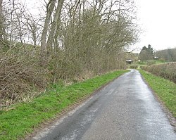
Belses consists of two hamlets south of the Ale Water, in the midst of Roxburghshire. To the west is Old Belses, and to the east, at the end of a dead-end farm lane, is New Belses, which is in essence just one farm. The place is to the south of Newtown St Boswells, west of Jedburgh and north of Hawick. The nearest village of any size is Ancrum, four miles to the east.

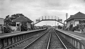
Belses was the site of a railway station on the former Waverley Line, a double track railway which linked Edinburgh with Carlisle, on the North British Railway. The line closed in 1969. While part of the line has reopened, as the Borders Railway, the stretch past Belses remains abandoned for now.
Outside links
| ("Wikimedia Commons" has material about Belses) |
- RCAHMS entry for Belses Station
- SCRAN: image of a North British Railway Stencil
- Robin Barbour collection: Images of Belses Station from the 1960s
- Waverley Route Heritage Association
References
- Evans,D (1985) 'Practical Plans, Stow and Belses', Practical Model Railways, vol.June 1985, page(s):32-3
