Stagehall
| Stagehall | |
| Midlothian | |
|---|---|
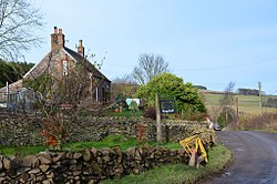
 Cottage at Stagehall Farm | |
| Location | |
| Grid reference: | NT455445 |
| Location: | 55°41’27"N, 2°52’7"W |
| Data | |
| Local Government | |
| Council: | Scottish Borders |
Stagehall is a hamlet in Midlothian, on the west side of the Gala Water opposite Stow. It is deep within the Moorfoot Hills, connected to Stow by a single bridge over the river and otherwise joined to the world by a singe lane running up and down the west bank of the Gala Water.
The railway line up the dale of the Gala Water, known as 'the Waverley Route' ran through Stow from 1849 until it was closed in 1969 - a victim of the Beeching Axe. The line long lay abandoned. However in 2014-2015 new track was laid for what was named "the Borders Railway" and the line was opened to passengers in September 2015. Stow Station on the Borders railway is at Stagehall.
Over the brow of Stagehall Hill, behind the village, are the remains of Ewes Castle.