Mountain Cross
From Wikishire
Revision as of 21:04, 30 November 2016 by RB (Talk | contribs) (Created page with "{{Infobox town |name=Mountain Cross |county=Peeblesshire |picture=Grazing land below Wood Hill - geograph.org.uk - 1393879.jpg |picture caption=Grazing land below Wood Hill |o...")
| Mountain Cross | |
| Peeblesshire | |
|---|---|
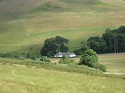
 Grazing land below Wood Hill | |
| Location | |
| Grid reference: | NT150468 |
| Location: | 55°42’26"N, 3°21’15"W |
| Data | |
| Post town: | West Linton |
| Postcode: | EH46 |
| Local Government | |
| Council: | Scottish Borders |
Mountain Cross is a little village in Peeblesshire, on the A701 road between Romannobridge and Blyth Bridge.
In spite of its name, this village is not among the county's wild fells, but in the fertile farmland between two ranges of hills, the Pentland Hills to the north-west and the Moorfoot Hills to the south-east. It is half a mile north-east of Blyth Bridge, on the tongue of land between the Longstruther Burn and the Lyne Water.
Outside links
| ("Wikimedia Commons" has material about Mountain Cross) |