Cardrona
| Cardrona | |
| Peeblesshire | |
|---|---|
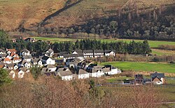
 Cadrona from the hilsides | |
| Location | |
| Grid reference: | NT300390 |
| Location: | 55°38’24"N, 3°6’44"W |
| Data | |
| Post town: | Peebles |
| Postcode: | EH45 |
| Local Government | |
| Council: | Scottish Borders |
Cardrona is a village sitting in a bend in the River Tweed in Peeblesshire. It is to be found at the junction of the A72 and B7062 roads, between Peebles and Innerleithen.
At the western edge of the village is the Cardrona Standing Stone.[1]
The village stands in Tweeddale by the river, but immediately to the south the hills rise within the Cadrona Forest.
Places nearby include Glentress, Kirkburn, Kirkhouse, Traquair, and Walkerburn.

Name
The name Cardrona is unusual in its form for this area. Etymologically it appears to be a Cumbric place-name. The first element is cognate with Welsh caer, meaning 'fortification'. The second element is less clear but recent work suggests a word cognate with Welsh trwyn, literally 'nose' but attested in Welsh and Cornish place-names in the sense 'promontory'. If so, the name means something like 'fort of the promontories'.[2]
Outside links
- Cardrona village
- Megalithic Portal: Cardrona Standing Stone
- SCRAN File: Cardrona Viaduct, Cardrona, Peebles-shire
- Gazetteer for Scotland: Cardrona@
- Forestry Commission: Cardrona
References
- ↑ Megalithic Portal: Cardrona Standing Stone
- ↑ Bethany Fox, 'The P-Celtic Place-Names of North-East England and South-East Scotland', The Heroic Age, 10 (2007), http://www.heroicage.org/issues/10/fox.html (appendix at http://www.heroicage.org/issues/10/fox-appendix.html).