Steventon, Berkshire
| Steventon | |
| Berkshire | |
|---|---|
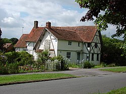
 Cruck Cottage, The Causeway, Steventon | |
| Location | |
| Grid reference: | SU465915 |
| Location: | 51°37’12"N, 1°19’48"W |
| Data | |
| Population: | 1,502 (2001) |
| Post town: | Abingdon |
| Postcode: | OX13 |
| Dialling code: | 01235 |
| Local Government | |
| Council: | Vale of White Horse |
| Parliamentary constituency: |
Wantage |
| Website: | Steventon Village Web |
Steventon is a village in Berkshire, found about 4 miles south of Abingdon and a similar distance west of Didcot.
Parish church
The parish church of St Michael and All Angels was built in the 14th century by the Flemish builders.
History
The village has a mediæval causeway. Built by local monks in the Middle Ages, it runs the whole length of the village along its historic east–west axis. The causeway ends near the Church of England parish church.
The Great Western Railway opened Steventon railway station in 1840. It was the main station for Oxford, 10 miles to the north, until in 1844 the line from Didcot to Oxford was opened. Steventon station continued to serve the village until British Railways closed it 1964.
About the village
Steventon has three public houses: the Cherry Tree, The Fox and the North Star, the North Star being the oldest of the three.
The annual Truck Festival is held at Steventon each July.
Outside links
References
Further reading
- Page, William; Ditchfield, P.H., eds (1924). A History of the County of Berkshire, Volume 4. Victoria County History. pp. 365–369.
- Pevsner, Nikolaus (1966). Berkshire. The Buildings of England. Harmondsworth: Penguin Books. pp. 227–228.