Wheal Frances
| Wheal Frances | |
| Cornwall | |
|---|---|
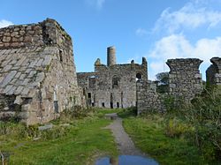
 The abandoned houses at Wheal Frances | |
| Location | |
| Grid reference: | SW786523 |
| Location: | 50°19’46"N, 5°6’43"W |
| Data | |
| Post town: | Truro |
| Postcode: | TR4 |
| Dialling code: | 01872 |
| Local Government | |
| Council: | Cornwall |
| Parliamentary constituency: |
Truro and Falmouth |
Wheal Frances is a village in Cornwall, near Perranzabuloe.
About the village
To the north of the village, Carnkief Pond has been designated a Site of Special Scientific Interest, noted for its biological interest, including twelve species of dragonfly.[1]
Wheal Frances Mine
The village is named after its mine, the Wheal Frances Mine, of which extensive ruins remain.[2]
References
- ↑ SSSI listing and designation for Carnkief Pond
- ↑ Gamble, Barry: Cornish Mines: St Just to Redruth (Alison Hodge Publishers, ISBN 978-0-906720-81-3 page 69