Sladesbridge
| Sladesbridge | |
| Cornwall | |
|---|---|
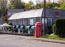
 Pub at Sladesbridge | |
| Location | |
| Grid reference: | SX011714 |
| Location: | 50°30’29"N, 4°48’12"W |
| Data | |
| Post town: | Wadebridge |
| Postcode: | PL27 |
| Local Government | |
| Council: | Cornwall |
Sladesbridge is a small village located near Wadebridge in Cornwall, standing at the meeting of the River Allen and the Croan Stream about half a mile upstream of the point where the Allen enters the River Camel. The surrounding area is in the Cornwall Area of Outstanding Natural Beauty and the floodplain is a Special Area of Conservation, a Site of Special Scientific Interest and a County Wildlife Site.
Economy
A number of businesses are estavlished in Sladebridge, including Slade's House Country Inn, Trelawney Garden Leisure, Knevitt Consulting Engineers, Wood Design Furniture and Kestle Quarry.
Flora and fauna
Otters, salmon, kingfishers, water rail and snipe are often seen in and around the river and the reedbeeds either side.[1][2] A footpath runs along the western edge of the river allowing the general public to view the wildlife.
Flooding
The village flooded very badly in June 1993 when the fire service had to rescue people from their properties. It had flooded to a lesser extent many other times over the years so following the Autumn 2000 floods, the government made additional funding available to enable the Environment Agency to promote a flood defence scheme for the area, including the hamlet of Clapper on the edge of Wadebridge.
The car park of the pub was the site of the opening of the Environment Agency's £1.8 million flood defence scheme in April 2004. The scheme was designed to fit into its surroundings with all walls built with slate to look like the local Cornish hedges and a 9 hectare wetland created to allow the rivers to reclaim their floodplain.
A new cycle track was created with the view to potentially linking the village with the Camel Trail. Over 4000 native trees and shrubs were planted as well and the completed scheme now protects all the properties and businesses in the village against a flood with a 1.3% chance of occurring in a year.
Outside links
| ("Wikimedia Commons" has material about Sladesbridge) |
References
- ↑ Corwall Rivers Project: Camel and Allen
- ↑ SSSI listing and designation for River Camel Valley and Tributaries
