Michaelston-super-Ely
| Michaelston-super-Ely Welsh: Llanfihangel-ar-Elai | |
| Glamorgan | |
|---|---|
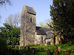
 St Michaels Church | |
| Location | |
| Grid reference: | ST125755 |
| Location: | 51°28’34"N, 3°16’12"W |
| Data | |
| Post town: | Cardiff |
| Postcode: | CF5 |
| Dialling code: | 029 |
| Local Government | |
| Council: | Cardiff |
| Parliamentary constituency: |
Cardiff West |
Michaelston-super-Ely is a village and ancient parish in Glamorgan to the west of the city of Cardiff. The suffix "super Ely", descriptive of its location on the River Ely, is necessary to distinguish the parish from others nearby, namely Michaelston-le-Pit and Michaelston-y-Fedw.
To the north lies the village of St Fagans, and to the east the Ely estate.
The historic St Michael's Church was deconsecrated in 2010. It is a Grade II* listed building dating from the late 12th or early 13th-century.[1]
References
- ↑ "Church of St Michael, St Fagans". British Listed Buildings. http://www.britishlistedbuildings.co.uk/wa-13926-church-of-st-michael-st-fagans#.VsCP50BRSx0. Retrieved 14 February 2016.
Outside links

This Glamorgan article is a stub: help to improve Wikishire by building it up.