Penllyn
| Penllyn | |
| Glamorgan | |
|---|---|
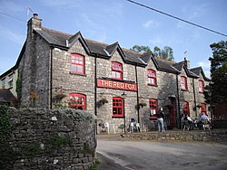
 The Red Fox, Penllyn | |
| Location | |
| Grid reference: | SS973761 |
| Location: | 51°28’31"N, 3°28’48"W |
| Data | |
| Population: | 1,506 (2011[1]) |
| Post town: | Cowbridge |
| Postcode: | CF71 |
| Dialling code: | 01446 |
| Local Government | |
| Council: | Vale of Glamorgan |
| Parliamentary constituency: |
Vale of Glamorgan |
Penllyn is a village and parish in Glamorgan, located north-west of the market town of Cowbridge.
Penllyn is home to Penllyn Castle, a 12th-century fortification which, although ruinous, is now adjoined by a castellated mansion originally built in the late 16th century.
The smaller hamlet of Graig Penllyn, about a mile and a half north of the main village, is notable for its pub the Barley Mow.[2][3]
Notes
- ↑ "Community population 2011". https://neighbourhood.statistics.gov.uk/dissemination/LeadKeyFigures.do?a=7&b=11127483&c=CF71+7TQ&d=16&e=62&g=6494301&i=1001x1003x1032x1004&m=0&r=0&s=1428585408840&enc=1. Retrieved 9 April 2015.
- ↑ http://cowbridgeguide.co.uk/pubs/thebarleymowinn
- ↑ http://whatpub.com/pubs/VAL/V034/barley-mow-craig-penllyn

This Glamorgan article is a stub: help to improve Wikishire by building it up.