Marchington
| Marchington | |
| Staffordshire | |
|---|---|
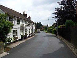
 Church Lane in Marchington | |
| Location | |
| Grid reference: | SK132308 |
| Location: | 52°52’30"N, 1°48’11"W |
| Data | |
| Post town: | Uttoxeter |
| Postcode: | ST14 |
| Dialling code: | 01283 |
| Local Government | |
| Council: | East Staffordshire |
| Parliamentary constituency: |
Burton |
Marchington is a small village and parish in Staffordshire, adjacent to the border with Derbyshire. It lies between the towns of Burton upon Trent and Uttoxeter. Marchington has a small shop, a first school, two churches and two pubs. The population of the village was 1,127 at the 2001 census,[1] increasing to 2,017 at the 2011 census.[2]
History
One of the earliest mentions of Marchington is in an manuscript held in the British National Archives; A.D. 951. King Eadred to Wulfhelm, miles; grant of land at Marchington, Staffs. Marchington is mentioned in the Domesday Book where it is listed amongst the lands given to Henry de Ferrers[3] by the King. The land consisted of four and a half square leagues of woodland and meadow; 40 acres of pasture and work for more than seven ploughs. It was worth one hundred shillings. The lands remained in the ownership of the de Ferrers family as part of the earldom of Derby until the failure of the rebeilion of Robert de Ferrers, 6th Earl. After his death in 1279, his widow, Eleanor, failed in a legal case to prove that she had a dower interest in the land. The lands were then held by the king's brother, Edmund, 1st Duke of Lancaster.
A railway station on the Crewe to Derby line opened in 1848 but closed in 1958.
In 1941 a US army camp was built in Marchington. The vicarage became the headquarters and an officers’ mess was built in Silver Lane. It became a prisoner-of-war camp in 1944 when the soldiers left for the D-Day invasion of Europe. The British army was still using the camp until the 1960s but the land was finally sold in 1980.
Geography
Marchington is 270 ft above sea level. It lies adjacent to the River Dove which marks the border between Staffordshire and Derbyshire. There is a small brook in the village; towards the River Dove there is a flood plain. Toot Hill lies to the north-west and Hound Hill to the east. The National Forest also lies nearby, to the south of the village.
Economy

There is a large industrial estate to the south of the village. It previously housed the military's fleet of 'Green Goddess' fire tenders.[4]
Today the majority of the residents work in nearby town such as Uttoxeter and Burton-on-Trent. However, some work further afield in Derby, Stoke-on-Trent and Birmingham.
Culture and recreation
There is a large playing field to the east of the village. Marchington also has a village hall on the square.

Religion
St Peter's is the local Parish Church and is a brick building dating from 1742. It is the only church in the ecclesiastical parish of Marchington, St Peter. Marchington previously had a Wesleyan Methodist chapel on Bag Lane that opened in 1840 and closed in 1970, It is now in private ownership. The village's Roman Catholic church on Hall road is a small stone building and is part of the Roman Catholic Archdiocese of Birmingham.
References
- ↑ 2001 census Staffordshire
- ↑ "Civil Parish population 2011". http://www.neighbourhood.statistics.gov.uk/dissemination/LeadKeyFigures.do?a=7&b=11126305&c=Marchington&d=16&e=62&g=6463227&i=1001x1003x1032x1004&m=0&r=1&s=1449747913568&enc=1. Retrieved 10 December 2015.
- ↑ Domesday Book: A Complete Transliteration. London: Penguin, 2003. p.679 656-7 ISBN 0-14-143994-7
- ↑ Exploring Marchington Barracks, Former Royal Army Ordnance Corp & Vehicle Depot
Outside links
| ("Wikimedia Commons" has material about Marchington) |
