Medbourne
| Medbourne | |
| Leicestershire | |
|---|---|
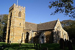
 St Giles Church, Medbourne | |
| Location | |
| Grid reference: | SP800930 |
| Location: | 52°31’44"N, 0°49’20"E |
| Data | |
| Population: | 473 (2011) |
| Post town: | Market Harborough |
| Postcode: | LE16 |
| Dialling code: | 01536 |
| Local Government | |
| Council: | Harborough |
Medbourne is a village and parish in south-eastern Leicestershire, adjacent to the border with Northamptonshire. The population of the civil parish at the 2011 census was 473.[1]
Each year it competes with nearby Hallaton during the Bottle-kicking event on Easter Monday. It is believed that Medbourne, which lay on the Gartree Road, was a large market settlement at the time of Roman Britain.
The Village
Medbourne is a small, tranquil village just ten minutes from Market Harborough and fifteen minutes from Uppingham. The village has its own shop, known as village stores and a pub. The railway station closed as long ago as 1916. It is regarded as the most sought-after village to live within the Welland Valley.
The Sports & Social Club is on the Hallaton Road on the edge of the village and is home to the local football and cricket teams. Despite being in Leicestershire Medbourne F.C. play in the the Northamptonshire Combination.
References
- ↑ "Civil Parish population 2011". Neighbourhood Statistics. Office for National Statistics. http://www.neighbourhood.statistics.gov.uk/dissemination/LeadKeyFigures.do?a=7&b=11126441&c=Medbourne&d=16&e=62&g=6444722&i=1001x1003x1032x1004&m=0&r=1&s=1466157302766&enc=1. Retrieved 17 June 2016.
Outside links
| ("Wikimedia Commons" has material about Medbourne) |

This Leicestershire article is a stub: help to improve Wikishire by building it up.
