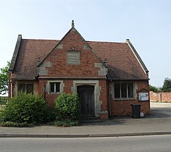
Theddingworth
| Theddingworth | |
| Leicestershire | |
|---|---|
 Theddingworth Village Hall | |
| Location | |
| Grid reference: | SP668855 |
| Location: | 52°27’56"N, 1°1’7"W |
| Data | |
| Population: | 217 (2011) |
| Post town: | Lutterworth |
| Postcode: | LE17 |
| Local Government | |
| Council: | Harborough |
Theddingworth is a village and parish in Leicestershire adjacent to the border with Northamptonshire. The population of the civil parish at the 2011 census was 217.[1] The ancient parish includes the neighbouring hamlet of Hothorpe, which lies across the county border in Northamptonshire.
Theddingworth lies about five miles west of Market Harborough on the road to Lutterworth. It is on the north bank of the River Welland, which forms the county border with Northamptonshire. The Grand Union Canal passes within a mile. There is a church and Congregational Chapel. Theddingworth railway station was a former stop on the Rugby to Market Harborough line.
References
- ↑ "Civil Parish population 2011". Neighbourhood Statistics. Office for National Statistics. http://www.neighbourhood.statistics.gov.uk/dissemination/LeadKeyFigures.do?a=7&b=11129528&c=Theddingworth&d=16&e=62&g=6444614&i=1001x1003x1032x1004&m=0&r=1&s=1466588801172&enc=1. Retrieved 22 June 2016.
Outside links
| ("Wikimedia Commons" has material about Theddingworth) |
- 'Theddingworth', A History of the County of Leicester: Volume 5: Gartree Hundred (1964), pp. 312–321. Accessed: 7 September 2008

This Leicestershire article is a stub: help to improve Wikishire by building it up.
