Crowlas
| Crowlas | |
| Cornwall | |
|---|---|
 Crowlas | |
| Location | |
| Grid reference: | SW515331 |
| Location: | 50°8’46"N, 5°28’46"W |
| Data | |
| Post town: | Penzance |
| Postcode: | TR20 |
| Local Government | |
| Council: | Cornwall |
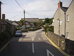
Crowlas is a village in Cornwall. It is on the A30 road about three miles east of Penzance and forms a little conurbation with Ludgvan Lower Quarter, within the parish of the same name. The hamlet of Whitecross lies to the north.

Outside links
| ("Wikimedia Commons" has material about Crowlas) |
References

This Cornwall article is a stub: help to improve Wikishire by building it up.
