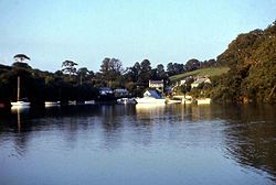
Coombe, Kea
For other like-named villages in Cornwall, see Coombe, Cornwall
| Coombe | |
| Cornwall | |
|---|---|
 Coombe | |
| Location | |
| Grid reference: | SW836409 |
| Location: | 50°13’42"N, 5°2’8"W |
| Data | |
| Local Government | |
| Council: | Cornwall |
Coombe is a hamlet in Cornwall on the east side of Cowlands Creek, a tributary of the River Fal. It is two and a halh miles south of Truro as the crow flied but far further by the winding lanes which link it eventually to the rest of the land. Coombe is in the Parish of Kea, whose own little villages, Old Kea and Porthkea stands to north-east and north-west respectively.
This is one of a number of villages of the same name in Cornwall: the name is from the Old Cornish kumb, meaning 'valley', possibly in some cases by way of the Old English cumb.
Coombe is within the 'Cornwall Area of Outstanding Natural Beauty' as is almost a third of the county.
Outside links
| ("Wikimedia Commons" has material about Coombe, Kea) |
