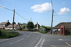
Ladycross
From Wikishire
Revision as of 13:07, 13 July 2016 by RB (Talk | contribs) (Created page with "{{Infobox town |name=Ladycross |county=Devon |picture=Werrington, Ladycross - geograph.org.uk - 457056.jpg |picture caption=Ladycross |os grid ref=SX320882 |latitude=50.670797...")
| Ladycross | |
| Devon | |
|---|---|
 Ladycross | |
| Location | |
| Grid reference: | SX320882 |
| Location: | 50°40’15"N, 4°22’45"W |
| Data | |
| Local Government | |
| Council: | Cornwall |
Ladycross is a hamlet in western Devon, within the part of that county which extends a finger to the west of the River Tamar, surrounded on three sides by Cornwall.
The hamlet is close to Werrington (also in Devon's west-of-Tamar finger), on the B3254 road half a mile north of Yeolmbridge.