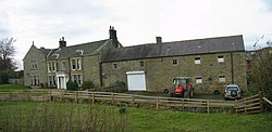
Melkridge
| Melkridge | |
| Northumberland | |
|---|---|
 Allensgreen Farm at Melkridge | |
| Location | |
| Grid reference: | NY738639 |
| Location: | 54°58’8"N, 2°24’32"W |
| Data | |
| Population: | 216 (2011) |
| Post town: | Haltwhistle |
| Postcode: | NE49 |
| Dialling code: | 01434 |
| Local Government | |
| Council: | Northumberland |
| Parliamentary constituency: |
Hexham |
Melkridge is a village in Northumberland, on the river South Tyne. The village is about two miles east of Haltwhistle along the A69 road, and remains a modest place, with a population of 216 counted in 2011.
About the village
Melkridge is the locus of prehistoric settlement dating to about 500 to 2500 BC.[1]
Melkridge has no railway station, despite its proximity to the tracks of the Newcastle to Carlisle line, served by Northern Rail. The nearest stations to Melkridge are at Bardon Mill and Haltwhistle.
Outside links
| ("Wikimedia Commons" has material about Melkridge) |
